 DC Real Estate Development: There's An App For That
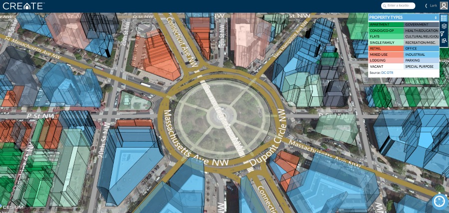
Dupont Circle, as seen through Create. Click to enlarge.
When UrbanTurf first wrote about Create, the real estate mapping tool intended to aid development, we asked whether it would become a developer’s best friend. Now that the application has launched, it turns out to be useful to an even broader audience.
Create’s intent is to help developers figure out whether or not a given piece of real estate is feasible for development. It’s the brainchild of 29-year-old real estate analyst Stefan Martinovic, who thought he could streamline and automate some of the early steps in the development process, like feasibility, site selection, high-level budgeting and financial analysis. The site does that; for example, it can filter through properties, showing a user all the residentially-zoned vacant lots less than 0.5 miles from a Metro, for example, a feature with obvious utility for a developer.
But it’s also an integration tool. Users of the software can find out a host of data about a given property with a simple search — including information on the owner, property value, square footage, materials, year built, permitting, zoning and more — as well as information on the neighborhood (organized by census tract), from the median income to the percentage of owner-occupied homes. Also included is transit data, like the property’s walk score, the distance to the closest Metro and how many people in the area own cars.
One caveat is that the information is only as good as its data sources; Martinovic tells UrbanTurf that Create updates automatically whenever those sources are updated, which happens “as often as daily,” he says. But getting 3D satellite images of buildings in the District is a complex process given airspace protections. The team at Create is currently working to integrate new images from a recent flyover into the app.
At the most basic level, the tool does what DC government websites, like the notoriously buggy District of Columbia Zoning Map, have been unable to do: It integrates different types of public data from various sources in a way that’s visual, easy to understand, and simple to navigate and search. Though Create is still a start-up with features to add and bugs to work out, it’s a tool that should be useful for not just developers but anyone interested in a particular DC property, from renters to ANC commissioners.
Martinovic says it’s already being used by employees of developers (including Vornado, Jair Lynch and WeWork); brokerages (Streetsense, Long and Foster and Keller Williams); and some government organizations, including the office of the Deputy Mayor for Planning and Economic Development and the the Department of the Environment.
The data platform for Create will be free with premium features available on a paid subscription basis. Martinovic tells UrbanTurf that premium features, including financial modeling, Excel integration, and the capability to add the user’s own data sets, will be available by the second quarter of 2015.
See other articles related to: create, development
This article originally published at https://dc.urbanturf.com/articles/blog/create_app_gives_users_a_better_look_at_dc_data/9437.


Play to hear Jen in her own words


UrbanTurf Listings showcases the DC metro area's best properties available for sale.

Most Popular... This Week • Last 30 Days • Ever

UrbanTurf takes a look at the residential projects in the works on the Maryland and D... read »
DC and Virginia lead the way in terms of where prices have risen the most this year.... read »
When it comes to financing a home purchase, a 30-year mortgage is one of the most com... read »

Bright MLS reported that DC-area home prices approached record highs in March as new ... read »

2709 N Street is a modern, expertly renovated condominium that was built out a of cen... read »


- Malls, Trader Joe's and The 1,400 Units Coming to Friendship Heights
- The 5 DC-Area Zip Codes Where Home Prices Have Appreciated the Most in 2024
- A Look at the Alternatives to a 30-Year Mortgage
- DC-Area Home Prices Nearly Break Record in March
- Three Exclusive Condominiums Debut in Expertly Renovated Georgetown Church
DC Real Estate Guides
Short guides to navigating the DC-area real estate market
We've collected all our helpful guides for buying, selling and renting in and around Washington, DC in one place. Start browsing below!
First-Timer Primers
Intro guides for first-time home buyers
Unique Spaces
Awesome and unusual real estate from across the DC Metro