An ice storm and a hurricane. They sound like they occupy completely opposite ends of the weather spectrum. If this were politics, one is like a far-left Democrat, the other a far-right Republican.
Yet for at least part of Thanksgiving weekend 2015, we saw both on our weather map.
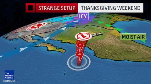
Before we go further, Hurricane Sandra in the eastern Pacific Ocean did not cause the freezing rain/sleet event in the Plains states, one facet of Winter Storm Cara.
However, you may wonder how these two disparate meteorological phenomena can at least exist at the same time in somewhat close proximity.
Sandra: Very Late
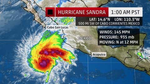
There have been only three other eastern Pacific storms of record dating to 1949 that formed later in the season than Sandra did on November 24. Sandra is the latest storm in the eastern Pacific since Hurricane Winnie was a December oddball in 1983. It became the latest major hurricane on record on Wednesday and intensified to a Category 4 hurricane early on Thanksgiving Day.
El Niño seasons such as the one we're currently in typically feature lower wind shear over the eastern Pacific basin, which otherwise rips developing or active tropical cyclones apart.
Sandra formed in a relatively small window of lower wind shear, and also capitalized on water temperatures from 1 to 1.5 degrees Celsius above average to fuel its convection.
(MORE: Strong El Niño to Peak in Winter | 2015 Likely Globe's Hottest Year on Record)
If you booked a Thanksgiving weekend getaway to Los Cabos or Mazatlan, I bet you didn't consider a tropical storm, as few would in late November.
Sandra became "sheared out" by the jet stream, thankfully, upon its approach to the Baja, weakening it quickly, and it never officially made landfall. However, some soaking rain occurred in the southern Baja peninsula and parts of mainland Mexico to the east with Sandra.
Ice Event a Little Early
Winter Storm Cara, together with a potent plunge of Arctic air, set the stage for sleet and freezing rain in the Plains as far south as parts of West Texas and eastern New Mexico.
(MORE: Winter Storm Cara Snow/Ice)
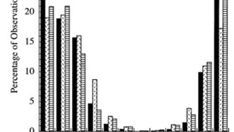
A 2003 study by Stanley Changnon and Thomas Karl of freezing rain in the Lower 48 States from 1948-2000 found December or January to be the peak months for ice events in the Plains region targeted by Winter Storm Cara.
One year later, a second study led by John Cortinas of the University of Oklahoma examining the U.S. and Canada together over a 15-year period from 1976-1990 found November only was fifth behind January, December, February and March in the distribution of all observations with freezing rain.
Of course Cara's ice was less than a week away from December, but this event does skew early, climatologically speaking.
Again, it didn't appear much, if any, of Sandra's remnant moisture ever made it far enough north to "seed" the ice event, as it were. Most of that moisture was wrung out over Mexico or was drawn well to the east-northeast perhaps contributing to heavy rainfall in parts of the southern Plains and Lower Mississippi Valley.
So, a very late tropical cyclone plus an early ice event lead to this bizarre holiday weekend weather potpourri.
Seeing the potential for Sandra to still be a tropical depression Saturday as little as 400 miles away from an area of freezing rain is a cool, weather geeky factoid you can add to an already bizarre 2015.
And, by the way, if you think hurricanes can't feed into winter storms, remember Superstorm Sandy's wintry side just over three years ago?
Jonathan Erdman is a meteorologist at weather.com and has been an incurable weather geek since a tornado narrowly missed his childhood home in Wisconsin at age 7. Follow him on Twitter and Google Plus.
MORE ON WEATHER.COM: Hurricane Patricia Hits Mexico Oct. 2015 (PHOTOS)


