I was first taught to read a map when I was around 11 years old. My stepfather shook out the Ordnance Survey OL30 Explorer map (Yorkshire Dales – Northern & Central Area) over the kitchen table in our holiday cottage: a paper tablecloth of sandy yellow and duck-egg blue, whorled with orange skeins. The map's text resembled a fantasy language: Oliver High Lathe, Gollinglith Fleet, Grouse Butts, Washfold Wham, Sprs, Resr (dis), Flaystones, Batty Nick, Acoras Scar, Shake Holes, Horse Helks, Three Holes Stoop (BS). Some of its symbols were relatively straightforward to decipher, such as a miniature telephone handset, teepee or blue fish. But others – like the menu of subtly differentiated dotted lines, or randomly placed numbers in varying fonts, colours and angles – made no sense to me.
Leaning over the map, my stepfather began sifting names I recognised. He ran his thumb along familiar paths and identified faraway landmarks my parents had pointed out during walks. He deciphered a line of green diamonds as a "National Trail/Long Distance Route" and distinguished it from a chain of black pinpricks (Boundary: Civil Parish (CP)) or tiny segregated dashes (Electricity Transmission Line). He encouraged me to imagine myself, a tiny speck, crawling over the paper landscape. He explained that the tighter the orange contour lines were bunched, the heavier I'd feel as I made my way across them; and that at points where the path disappeared, I could find my place on the map by attending to details I'd never before noticed: the coalescence of field boundaries, or a shift from "Bracken, heath or rough grassland" into "Scrub". He taught me how to line up the compass's red triangle at 0°, to lay it along the map's grid in the direction of north, to identify a landmark and navigate a path towards it. A small blue triangle on the map was a "trig point" and generally promised a good view, he assured me. A miniature pint glass meant a much-deserved rest.
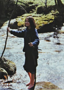
That first lesson in map reading irrevocably changed my idea of that glorious Nidderdale landscape; of all subsequent landscapes. Until I learned to map read, I had been hiking as if in a tunnel, flanked by dry-stone walls, blindly stumbling after my parents. Visible landmarks had passed on either side, as pleasantly unremarkable as sheep or daffodils. I had been rooted to ground level, eyes trained on the immediate vicinity. But the map broke down the walls of my tunnel vision, swept the ground from beneath my feet and launched me high in the air, elevating my mind's eye to a perch beside the bird's-eye viewpoint of the OS map. On that map, the world was laid out all before me; a carpet of fields, moors and possibilities. It's no coincidence, I think, that the earliest accounts of human flight compare the view of the landscape beneath to a map. Because it works both ways: hovering over a map is like flying.
Twenty-three years later, I'm still a confirmed map addict. I still visualise making my way through the world as a tiny speck, crawling across a map. If you ask me for directions, I'd much rather sketch you a map on the back of an envelope than recite an itinerary of right and left turns. Before a long run, I squirrel away in my memory details from the OS map in my backpack; emergency provisions for the imagination that will fuel unanticipated detours from my planned route and return me safely home.
The freedom that maps bestow to wander at leisure across the nation has granted Ordnance Survey's maps in particular an affectionate place in the hearts of map readers across centuries. The abundance of bird's-eye views in poetry, fiction and art testifies to a creative, active, imaginative relationship between the map-reader and their charts. These types of maps have appeared in literature as assertions of land ownership, patriotism and colonialism: Lear's "division of the kingdom" is executed on a map, and Heart of Darkness's Marlow entertains a "passion for maps", particularly a "large shining map [of Africa], marked with all the colours of a rainbow". Even in a satnav world, the tactility of paper maps punctuates modern poetry. Moniza Alvi depicts a woman "rub[bing] her face/ against a map of the world" or "roll[ing] like a map". Matthew Francis writes affectionately of "a mud-spattered map already separated / by too much folding into its nine panels". Paul Muldoon's "The Old Country" is nostalgic for a time when "Every glove compartment held a manual / and a map of the roads, major and minor".
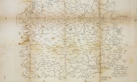
The conventions and aesthetics of paper maps also inspire imaginative responses, from poetry (Nigel Forde's "Conventional Signs" laments the failure of OS map symbols to convey the individual character of places) to modern mappae mundi, such as Grayson Perry's Map of Nowhere. The imaginative freedom granted by the bird's-eye view is obvious in the joy many writers and artists find in constructing maps of fantasy locations, from William Blake's "Corrected & Revised Map of the Country of Allestone" in 1806 to Tolkien's maps of Middle-Earth.
In comparison, satnavs seem to inspire few literary devotees beyond authors of humorous poems comparing their didactic nature to wives and back-seat drivers. In The Wild Places, Robert Macfarlane is scathing about the constrained viewpoint captured in road maps, writing that "it encourages us to imagine the land itself only as a context for motorised travel … The road atlas makes it easy to forget the physical presence of terrain, that the countries we call England, Ireland, Scotland and Wales comprise more than 5,000 islands, 500 mountains and 300 rivers." Arguably Daniel Defoe's linear routes around portions of Britain in his 1720s Tour Through the Whole Island of Great Britain were literary equivalents of contemporary road maps, but they were ultimately designed to be pieced together into a panoramic overview of the newly formed nation.
A satnav does the navigational graft for you. Maps coax their readers into doing the lion's share of the work. They require an act of code-breaking to distinguish the symbols for railway embankments from gravel pits; club houses from cattle-grids; coppice from saltings. They demand close attention to variations in the landscape and navigational initiative. But, as abundantly generous recompense for such active exertion, the bird's-eye view grants the freedom to eschew efficiency, to choose one's own path, to wander, improvise and play among the hills. The freedom to get lost, and find oneself again. By stimulating and freeing the mind, the paper map is loved by poets, artists, hikers, historians, lovers, dreamers.
But, as sales of paper maps decline year-on-year, and usage of digital apps and devices rises, there is a sea change taking place in the way we consume and use geographical information. Could this mark the end of the map, and if so, should we be worried?
Evidence for the waning popularity of the paper map is clearly visible in sales figures provided by Ordnance Survey, Britain's national mapping agency. OS has been synonymous with paper maps since the publication of its first map, in 1801, of Kent: a military survey designed to assist Britain's defensive efforts against revolutionary France. The stunning covers designed by Ellis Martin for the one-inch-to-the-mile Popular Edition in the interwar period secured for Ordnance Survey's folded maps an iconic status among hikers and cyclists, and today OS accounts for 95% of the share of the UK paper map sector. But, although the deterioration of sales of OS paper maps is slower than that experienced by its rivals, the organisation has nevertheless reported a 5% year-on-year decline in purchases of its staple Explorer and Landranger series of folded maps.
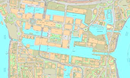
The 2004 framework document that set out Ordnance Survey's future priorities unequivocally stipulates that the organisation's chief responsibility (the source of 93% of its revenue) is to maintain and improve its massive geospatial database, the OS MasterMap. Beside this gargantuan task, the much-loved paper maps, and the leisure market that craves them, risk looking like a sideline. The MasterMap is primarily used to license different types of digital information to the private and state sector, such as a recent project to supply data necessary to underpin a Scottish Road Works Register (SRWR), a centralised record of road works in Scotland. And it is a jaw-dropping achievement: updated up to 10,000 times a day, the MasterMap is the most up-to-date, comprehensive and detailed bank of national geographical information owned by any country on Earth. Indeed, some feel that the database's driving commitment to "up-to-dateness" is at odds with the ethos of paper maps. Rapid changes affecting areas of the British Isles mean that many maps are out of date by the time they reach bookshops' shelves. Most of the Explorer and Landranger series are only updated every two to five years. So to combat the paper map's inbuilt tendency to obsolescence, Ordnance Survey has been developing apps to equip hikers and cyclists with the most recent digital geographical information. Some (such as OS MapFinder and OS Ride) could entirely replace paper maps, but others (such as OS Locate, which provides users with National Grid References for their location) are designed to act as companions.
However, the organisation is acutely "aware of the fact that customers love [paper maps]" and of the "passion and iconic image" they produce, Robert Andrews, head of corporate communications at OS, assures me, and recent media reports that some of the OS's Explorer and Landranger series will soon be available only on a "print-on‑demand" basis turn out to be unfounded. "Maintaining a national series of [paper] maps" remains a firm statutory commitment of Ordnance Survey, Andrews promises. And he dismisses suggestions that the organisation's duty to continue printing these maps might be contrary to its commitment to the database. Instead he points out that the two actually exist hand-in-hand. Even the OS's decision in 2010 to outsource the printing and warehousing to private firms doesn't really seem to indicate an abdication of responsibility for the artefacts themselves. (Ordnance Survey's history has been punctuated by similar outsourcing of its maps' publication: even its first map was printed not by OS's military headquarters but by William Faden, royal geographer to King George III.)
It is true that all Ordnance Survey's leisure products combined – paper maps and their modern-day heirs, mobile phone apps – are now only responsible for 7% of the organisation's overall revenue. But within that sector, paper maps continue to be the OS's most popular product: 1.9m were sold last year, compared to around 200,000 downloads of their digital equivalent. Even at a technological level, a paper map has a clear advantage over a satnav or mobile phone: it won't run out of batteries or lose signal at the top of a mountain, just as the clouds close in.
It should come as no surprise that the OS paper map refuses to die without a fight – it has been exciting loyalty and love among its users since its earliest days. Despite OS being established as a military survey in 1791, its first real director – a visionary called William Mudge – foresaw the possibilities that a complete, accurate national map might offer the general public. In all its applications, from improved scientific knowledge of the Earth to furthering the progress of the incipient industrial revolution, he predicted that it would be "the Honour of the Nation". Mudge successfully proposed selling maps to the public (albeit at prohibitive cost: three guineas per county survey – the average weekly wage of one of the engravers of the early maps), and oversaw the publication of accounts of his mapmakers' endeavours, priced to reach an audience far wider than military engineers or geographical scientists.
The French revolutionary and Napoleonic wars placed a premium on up-to-date, detailed geographical knowledge of Britain's borders. When his superiors sought to classify such information, Mudge fought hard – but unsuccessfully – for continued public access to the maps. But the 19th century saw Ordnance Survey's readership expand, as the price of its maps steadily decreased and the number of licensed retailers rose. By 1848 OS maps were no longer the preserve of "gentlemen [who wanted] to procure a map of the country surrounding their own habitations" for proud display, as an 1818 advert had suggested, but were placed, in the words of the Daily News, "within the reach of all who may require such aid".
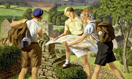
OS maps had not been formally linked to the cult of landscape that dominated the literary and leisure culture of their earliest years: after all, who folds a £100 map into their pocket or exposes it to the British weather? That association was cemented later, during the interwar period that saw the introduction of a new, stylish, affordable series of folded one-inch tourist maps to exploit the extraordinary explosion of enthusiasm for hiking, cycling and immersion in the British outdoors. John Betjeman recalled exploring "Dear lanes of Cornwall! With a one-inch map, / A bicycle and well-worn Little Guide" and James Walker Tucker's 1936 painting, Hiking (cover image), shows a trio of beret-clad walkers clustered around an outspread map. By the end of the 20th century, Ordnance Survey's heady history of militaristic patriotism, technological advancement and association with fresh air and exercise had, in the eyes of many map addicts, granted its maps a status as "icons of England".
But there is something about paper maps, beyond their place in British culture and history, that inspires devotion in their owners. Many hikers recall with fond exasperation their struggles to return OS maps to neat concertinas, against the efforts of high winds to launch those intricately folded pieces of paper as kites. Map-readers through history have relished the anticipation of unfurling a paper map across a surface and poring over its panorama, excitedly homing in on home. And many maps are beautiful, their delicate shading and life-like depiction of groundcover elevated to an artform. Just as bound books trump e-readers across many emotional and aesthetic categories, the tactile nature of maps – from the vellum of medieval mappae mundi to the rolled estate surveys of large stately homes to the weatherproof coatings of OS's "active" maps – evoke an immediate sensual response that far surpasses reactions to their digital equivalents.
Neither can I believe that I was alone in experiencing the transformative effect of learning to read a map; of realising the imaginative potential of paper maps and their bird's-eye views. What I learned is that there are two principal ways of visualising landscape in the mind's eye.
The first traces an individual's route as it unravels like a ball of wool, taking in only those landmarks immediately visible on either side. It produces an image of space that is linear, continuous, seen from ground level or a little way above. Its communication of geographical information is sparse but extremely efficient, with no allowance for distractions or diversions. This method of representation – known as "traverse surveying" – undoubtedly has an important function, usually in purposeful navigation, when getting from A to B as fast as possible is the priority. It characterises road travel, from the route maps contained in 18th-century road books to their modern-day heirs, satnavs.
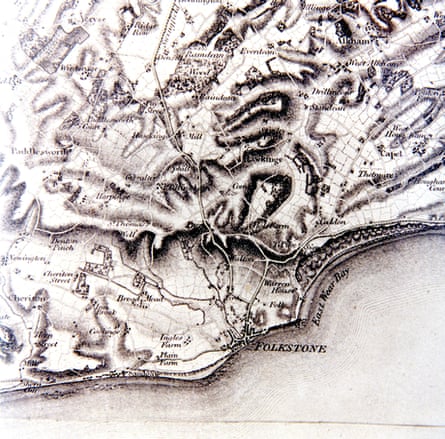
And then there is the bird's-eye view. A vision of landscape drawn from an elevated viewpoint, this produces what the poet James Thomson called "an equal wide survey" of a territory. Its image is emphatically non-linear, sprawling to the edges of the paper on which it is drawn. It doesn't reveal everything about a landscape – Jorge Luis Borges wrote of the absurdity of the intention to make a map on the scale of 1:1 – but its information is typically various, detailed, seemingly impartial. Its vocabulary of symbols is often obscure, and to read it requires active interpretative exertion – but this effort is repaid with the freedom to choose one's own route, and a far greater emotional connection between the map-reader, the map and the landscape. If the traverse survey mimics the viewpoint of the driver whose eyes are focused on the road ahead, then the bird's-eye view is the leisurely, expansive, panoramic gaze of the hiker, looking down from the top of a mountain.
These two very different forms inspire similarly different methods of engagement from their users. But both types of maps have their place, of course. Traverse surveys dominate the market in digital consumer navigation, particularly satnavs and other handheld devices, whose small screens are ideally suited to the swift display of pared-down information. And I'm grateful for these gadgets when I'm driving, or running purely for speed. But they encourage passivity. They keep us in ignorance of a world beyond the immediate vicinity. They suppress diversions from the fastest route. They quash active attempts to immerse ourselves, knee-deep in the bogs and fescue grass of the British countryside.
William Wordsworth wrote of "dreaming o'er the map": does anyone dream over a satnav? The end of the map is a decline in active engagement with our environment. Emotionally, physically, imaginatively: we will be poorer for it.
Rachel Hewitt's Map of a Nation: A Biography of the Ordnance Survey is published by Granta.
Comments (…)
Sign in or create your Guardian account to join the discussion