:format(webp)/cdn.vox-cdn.com/uploads/chorus_image/image/64887677/A_virtually_cloud-free_Europe_captured_by_MSG-1.0.0.1484394737.0.jpg)
Europe, as both a place and a concept, has changed dramatically in its centuries of history. Once one of the world's most war-torn places, it is now known for its remarkable peace. While a place of relatively great prosperity, it is also experiencing deep economic turmoil. Europe's transformations are still ongoing, evident both at the continental level and as narrowly as along certain transportation lines.
1) Members of the European Union
:format(webp):no_upscale()/cdn.vox-cdn.com/assets/4688257/european_union.png)
Europe is a contested and contestable concept, but one good place to start is with the contemporary members of the European Union — a concrete political instantiation of the idea of Europe. But the EU excludes some countries such as Norway and Switzerland that are canonically European and simply resist the political entanglements that membership would bring. The EU also includes the United Kingdom, many of whose residents believe “Europe” starts on the other side of the English Channel. The non-members in the Balkans are largely thought to be on track for eventual membership when they reach an appropriate level of political and economic development.
2) NATO’s growth over time
The North Atlantic Treaty Organization contains several members who aren’t European (the United States, Canada, and arguably Turkey) and excludes quite a few European nations. But its expansion over time is key to the construction of modern Europe. NATO was conceived of as an anti-communist military alliance. Initially, it was composed of countries that had fought together against Germany in World War II, but its anti-Soviet orientation and the heavy involvement of the United States created a context in which France and others could endorse the re-armament of West Germany. When Germany re-unified as a NATO member, rather than as a neutral, it set the stage for the alliance to continue expanding eastward and outlive the Cold War. In its modern form, the alliance is a source of security for western Europe, a source of customers for US arms manufacturers, and a source of tension with Russia.
3) Europe’s multinational institutions
:format(webp):no_upscale()/cdn.vox-cdn.com/assets/4719042/Supranational_European_Bodies.png)
Europe has a lot of international institutions. The European Union and its associated entities are the best-known and most-important of them. But the EU itself is complicated, and not every EU member is part of the EU’s currency union (the Eurozone) or its border security union (the Schengen Area). EEA and EFTA members largely participate in Europe’s “common market” for goods but don’t otherwise participate in EU political endeavors. The Euro minting agreement is with several micro-states considered too small for Eurozone membership but who nonetheless use the European currency. The Council of Europe, meanwhile, is a largely symbolic organization that casts the broadest net of all the European institutions.
4) Unemployment rate by region
:format(webp):no_upscale()/cdn.vox-cdn.com/assets/4719432/eurounemployment.png)
Politically, Europe is a continent of nation-states. But thanks to deep integration, the European economy is really one of regions where national averages can obscure more than they reveal. This map of unemployment rates coded by sub-national region shows how Europe really works. The strong German economy is really a case of a red-hot south Germany region that extends into adjacent areas of Austria, Switzerland, and the Czech Republic as much as it does into northwestern Germany. Meanwhile, the economy of the former East Germany looks a lot like the economy of Poland. Southern Italy is like Spain, Portugal, or Greece, but Northern Italy is more like France — so on average Italy shows up as an in-between case. The Francophone parts of Belgium have France-like economic conditions, while the Dutch-speaking parts in the north have conditions closer to those in the Netherlands. Transnational economic areas happen all over the world, of course, but the deep and purposeful economic ties European nations have forged with one another since the end of World War II make them an especially prominent aspect of the European experience.
History
5) The Roman Empire
:format(webp):no_upscale()/cdn.vox-cdn.com/assets/4822044/RomanEmpire_117.svg.png)
Many of Europe’s languages and institutions date back more or less linearally to the Roman Empire. This map (see 39 more Rome maps here) shows the empire at its greatest extent under Trajan in 117 A.D. Rome ruled substantial portions of North Africa and the Levant that today would be considered non-European, while excluding most of Germany, the Nordic countries, and most of central and eastern Europe. But the Christian religion formed in the later Roman years is a cornerstone of European culture, and the legacy of Rome lives on even outside the territory the empire formerly ruled. Titles such as Czar (Russian) and Kaiser (German) derive from Caesar, classical columns are a widely understood symbol of authority, and knowledge of Latin was for centuries considered the key mark of an educated person throughout the continent.
6) Europe in the fifth century
:format(webp):no_upscale()/cdn.vox-cdn.com/uploads/chorus_asset/file/671426/Roman-Empire_477ad.0.jpg)
By the late fifth century, the Roman Empire had collapsed in the west and Europe was a patchwork of small kingdoms, with the western Empire reduced to a handful of rump territories. Most of these kingdoms bore little relationship to modern day states, but the Ostrogothic kingdom does largely map onto present-day Italy, and the origins of modern-day Norway, Sweden, and Finland are discernible up north. On the other hand, the distinction between the present-day cultural zones of Europe and North Africa was not yet drawn at this time, as witnessed by a Vandal kingdom that encompassed territories on both sides of the divide. Similarly, Greece at this time was on the eastern side of an east/west political divide and united with Turkey — the opposite of the present-day arrangement.
7) The partition of Charlesmagne’s empire
:format(webp):no_upscale()/cdn.vox-cdn.com/assets/4719354/1280px-Partage_de_l_Empire_carolingien_au_Trait__de_Verdun_en_843.JPG)
Charles the Great, also known as Charlemagne, eventually united much of western Europe into a single kingdom. Upon his death in 814 A.D., his empire was formally divided into three pieces by the Treaty of Verdun in 843. The westernmost entity to emerge from the partition is clearly the antecedent of the modern-day state of France. The political history of Germany is more complicated, but, roughly speaking, it corresponds to the eastern kingdom. The territory in between, meanwhile, has been the site of much armed conflict in the 17th, 18th, 19th, and 20th centuries as France battled with Germanic powers ruled from Vienna and Berlin for control over the Low Countries, Alsace, and Lorraine.
8) The Holy Roman Empire
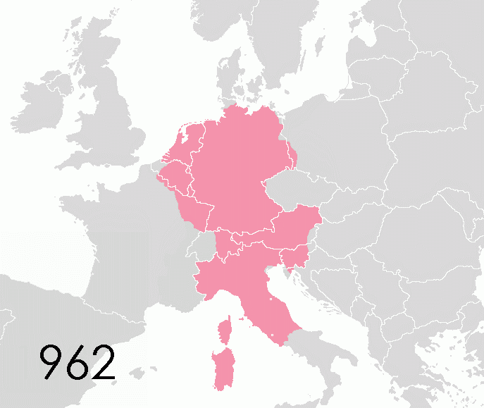
As the joke goes, the Holy Roman Empire was neither holy, Roman, nor an empire. It was, instead, the most prominent and important of a set of Medieval political institutions that did not develop the institutions of a modern state. The empire’s boundaries waxed and waned over time, but it was largely moribund by the 18th century as different monarchs — whether inside the empire or outside — sought to build their own powerful centralized kingdoms. When Napoleon’s armies marched across Europe, they abolished the Holy Roman Empire, and when he was defeated the victorious powers made no effort to put Humpty Dumpty back together again. Instead, the Habsburg Dynasty, which had long held the title of Holy Roman Emperor, simply began characterizing their holdings in Austria and Central Europe as an empire.
9) The empire of Charles V
:format(webp):no_upscale()/cdn.vox-cdn.com/uploads/chorus_asset/file/672218/Empire-Roman-Emperor-Charles-V.0.jpg)
He’s a bit of an obscure figure these days, but Charles V in the early 16th century ruled one of the mightiest empires the world had ever known. This map depicts his holdings in his function as King of Castille (purple), King of Aragon (red), Duke of Burgundy (orange), as well as holder of Austria’s hereditory territories (dark yellow), plus the then-extent of the Holy Roman Empire, throughout which he held some authority. What it doesn’t show is the vast expansion of the Spanish colonial empire at this time through the conquest of the Aztec and Incan empires in the New World.
10) Napoleon’s European Union
:format(webp):no_upscale()/cdn.vox-cdn.com/uploads/chorus_asset/file/671442/Screen_Shot_2014-08-25_at_2.38.09_PM.0.png)
This map shows Napoleon’s French Empire (deep blue) at its height in 1812, along with various satellite regimes that were typically headed by a member of the emperor’s family or one of his generals. The ruling regimes of Prussia and Austria were not deposed, but they were momentarily brought into a French-dominated continental economic order. But Britain and Russia were never reconciled to Napoleon’s ambitions, and rebellion was fairly constant in Spain — where the long border with British-aligned Portugal created many opportunities for troublemaking. France and its allies went to war with Russia to try to definitively establish the legitimacy of the new regime, but they were defeated decisively. Though Napoleon’s continental regime was short-lived, it was also quite influential, spreading the metric system and modern administrative methods throughout Europe.
11) The end of World War One
:format(webp):no_upscale()/cdn.vox-cdn.com/uploads/chorus_asset/file/676262/postwar_europe.0.png)
Napoleon’s defeat led to a century-long period without major continent-wide wars. Then came the Great War, an unexpectedly long and terrible conflict that shattered many of the dynasties that participated in it. This map highlights how Europe’s boundaries shifted as a result of the war (see 39 more World War I maps here). The borders established at the war’s end in late 1918 are by no means identical to today’s boundaries, but by this time the basic set of nations is becoming quite familiar, as is the rough principle that European states should conform to linguistically defined nations. The world war was followed by a second, even more terrible conflict that led to a further shrinkage of Germany and the expansion of the USSR.
12) The Iron Curtain
:format(webp):no_upscale()/cdn.vox-cdn.com/assets/4688361/Iron_Curtain_map.svg.png)
From 1948 through 1989, Europe was divided into two hostile, armed camps — one aligned with the United States of America and one aligned with the Soviet Union, with a handful of neutrals in between. The line separating the Soviet bloc from the rest was famously referred to by Winston Churchill as an “iron curtain” dividing Europe. But while on one level the Cold War divided the continent, in other respects it made it more unified than ever before. The threat of communism inspired the US-aligned nations to resolve longstanding conflicts and forge institutional ties. These relationships and institutions outlived the USSR and laid the foundation for modern Europe.
People
13) Europe’s many languages
:format(webp):no_upscale()/cdn.vox-cdn.com/assets/4784300/Rectified_Languages_of_Europe_map.png)
Political instability in other regions is often attributed to “arbitrary colonial boundaries” that fail to carve nationalities at the joints. But even in the historic homeland of linguistic nationalism, political boundaries rarely accord perfectly with social facts on the ground. German is the majority language in three countries. Spain contains four different language communities. There’s an Italian-speaking part of Switzerland and a German-speaking part of Italy. Substantial Francophone populations are living just outside France’s borders. And on the British Isles there are two (and maybe soon three) independent states sharing a common majority tongue.
14) Germany after reunification
:format(webp):no_upscale()/cdn.vox-cdn.com/uploads/chorus_asset/file/676202/GermanyPopulationChangeMap.0.jpg)
Germany has been unified for a quarter century now, but any statistical breakdown will reveal the enduring relevance of the old East/West divide in terms of prosperity, health, and almost anything else you care to name. The continued relevance of that boundary is also visible on this map of German population shifts (click through to see Benjamin Hennig’s full, gorgeous rendering). Almost all of the former East German areas are losing people. The exceptions are Berlin and the Berlin suburbs in the state of Brandenburg.
15) A Europe of equals
:format(webp):no_upscale()/cdn.vox-cdn.com/uploads/chorus_asset/file/671524/14489964857_2bd28e9483_o.0.png)
This fantasy map by Alasdair Gunn redivides the area contained in the European Union into states that would have roughly equal populations. For the sake of further fun, he’s tried to draw the boundaries to correspond to some real historical divisions in a way that gives us a look at some states that might have been. The southern and western shores of Sweden, for example, really were Danish possessions for a considerable period of time. Mainly, though, the map works as a clever illustration of population densities. Lowland, Köln, and Rhineland are all relatively tiny in terms of area but not population, underscoring the very thick settlement pattern in this portion of the continent. As one goes further east, things thin out considerably, and the make-believe countries get larger.
16) English language ability
:format(webp):no_upscale()/cdn.vox-cdn.com/assets/4596925/english-eu.jpg)
German is the most widely spoken native language in Europe, but English is the main language of continental affairs. It’s spoken by the multinational bureaucracy in Brussels, and it’s the language multinational business teams use to communicate internally. But competence in English is neither universal nor uniform across Europe. Across Europe’s southern tier, in particular, major decisions are being made in a language that is only spoken by a relatively narrow educated elite.
17) Europe by night
:format(webp):no_upscale()/cdn.vox-cdn.com/uploads/chorus_asset/file/18370507/dnb_land_ocean_ice.2012.3600x1800.jpg)
This map of the night sky from NASA is another way of getting at where Europeans actually live. The Russian population is fantastically concentrated in just a few cities, most prominently Moscow and St. Petersburg, which shine brightly amidst a dark countryside. But Europe’s biggest clusters of people are in England, around the Low Countries of Belgium and the Netherlands, and in the very prosperous northern region of Italy. A particularly noteworthy fact is how consistently lit-up the Mediterranean coast is, highlighting how central that sea has been for thousands of years of European settlement.
Economy
18) The richest person in every European country
:format(webp):no_upscale()/cdn.vox-cdn.com/uploads/chorus_asset/file/673704/152vuzj.0.png)
This fun map shows Reddit user Frivilligt’s best estimate of the richest person in every European country. There is no official government database of ultra-high-net-wealth individuals, so some media sources disagree about a few of the names. But the basic picture is clear enough. Unlike in a map of the richest resident of every American state, you don’t see any high-tech titans or fossil fuel barons here. It’s either the leaders of important consumer brands or else individuals whose wealth is drawn from the worlds of real estate and finance. If you’re wondering how Nutella could be so lucrative, the answer is that the Nutella you see on store shelves is only the most delicious confection made by a company that owns a portfolio of snack brands.
19) Europe scaled by GDP
:format(webp):no_upscale()/cdn.vox-cdn.com/uploads/chorus_asset/file/676126/Screen_Shot_2014-08-29_at_2.05.53_PM.0.png)
This cartogram from Benjamin Hennig distorts the shape of each European country to scale it to the size of its overall economic output. The rich, densely populated Netherlands gets a lot bigger though this method while sparsely populated Sweden and Ireland shrink. The picture should make it clear that Germany’s dominance of the continent — or even of the Eurozone, which excludes the United Kingdom — is often exaggerated. The Germans certainly have the largest economy in Europe but it’s far from a hegemonic position. France, Italy, and Spain are all quite large as well, and even the “small” European economies add up.
20) What does Europe export?
:format(webp):no_upscale()/cdn.vox-cdn.com/uploads/chorus_asset/file/674346/exports.0.png)
This detailed zoom into a larger map by Simran Khosla shows each country’s biggest export sector. Most European countries are global purveyors of sophisticated machinery and capital equipment of one sort or another, but there are exceptions. Norway combines a Nordic social democracy with a healthy supply of oil, making it the continent’s richest country by GDP per capita. Conversely, many of Europe’s poorer countries like Greece, Romania, or Portugal lack sophisticated manufacturing sectors and export less valuable commodities.
21) The unemployment divide
:format(webp):no_upscale()/cdn.vox-cdn.com/uploads/chorus_asset/file/676108/fredgraph.0.png)
Okay, this isn’t a a map at all. But it’s really important to understanding Europe. Before the financial crisis, the US unemployment rate was lower than the Eurozone’s, reflecting structural differences between the economies. Then the recession, focused initially in the American housing sector, hit the US much harder than the Eurozone and pushed the unemployment rates up to approximately the same level. But while the United States has made substantial progress in recovering from that shock, tight money from the European Central Bank and a chaotic financial situation have left the European job market dramatically worse off than it was at the peak of the initial recession.
22) Europe’s shale gas potential
:format(webp):no_upscale()/cdn.vox-cdn.com/uploads/chorus_asset/file/674866/20130202_WBM955.0.png)
Natural gas extracted from shale through hydraulic fracturing has been an enormous growth industry in the United States over the past five years, transforming a number of communities and sharply curtailing domestic use of coal. At the same time, many worry about the environmental hazards of the fracking itself, as well as about the potential for enthusiasm about new forms of fossil fuel extraction to kill momentum for renewable energy sources. This map from The Economist highlights that Europe may well have the potential to get in on the gas party. But not only does it take time and money to explore whether this potential can be brought to life, would-be frackers also need to overcome considerable regulatory hurdles. European politics makes it much easier for environmentalists and other fracking opponents to get their way, thus far limiting exploration to a great extent.
23) Tesla’s supercharger network
:format(webp):no_upscale()/cdn.vox-cdn.com/uploads/chorus_asset/file/674940/Screen_Shot_2014-08-28_at_9.37.22_AM.0.png)
This map of Tesla Motors’ European supercharger network is handy if you happen to be planning a road trip in an extremely expensive luxury sedan. But it’s also a window into Europe’s socioeconomic geography. This product appeals to a particular kind of upscale environmentalist, so it’s no surprise that Tesla’s US network started in California then came to the northeast and has been built from the coasts inward. The European equivalent is rather different, starting from the middle — along an axis running roughly from Turin to Oslo — and working out to less-prosperous regions on the eastern and western peripheries.
Life
24) Life expectancy
:format(webp):no_upscale()/cdn.vox-cdn.com/uploads/chorus_asset/file/674850/Screen_Shot_2014-08-28_at_9.08.31_AM.0.png)
Mapping life expectancy across Europe’s regions demonstrates an interesting lack of correlation with overall economic health. The former communist areas are uniformly worse than those on the western side of the Iron Curtain, but within western Europe it’s far from clear that the richer areas are doing better on this score. Spain has one of Europe’s weakest economies, but its life expectancy is among Europe’s highest. Greek life expectancy looks similar to Germany’s. Some of the worst life expectancies are concentrated in the prosperous United Kingdom. This is the sort of broad observation that’s given rise to a thousand articles touting the virtues of the Mediterranean diet and lifestyle versus the heavy investment in meat, potatoes, and beer that’s more characteristic of northern Europe or the United States.
25) Alcohol taxation
:format(webp):no_upscale()/cdn.vox-cdn.com/uploads/chorus_asset/file/674968/excise_map.0.jpg)
Alcohol taxation prices vary widely across Europe, with the general rule that the Nordic states and the UK levy the highest rates. This map was produced by Europe’s distilled spirits lobby, however, to illustrate the point that European nations generally tax alcohol at a higher rate when it comes in the form of whiskey or vodka than beer or wine. Wine in particular gets a very generous tax treatment, with a huge number of European states apparently viewing it as not having any kind of health hazard worth discouraging at all.
26) Share of population over 65
:format(webp):no_upscale()/cdn.vox-cdn.com/uploads/chorus_asset/file/674976/Europe_population_over_65.0.png)
This map based on 2010 data shows the share of the population in each country that is over the age of 65. Demographic aging is occurring in almost all countries around the world, but it is particularly extreme in a handful of European countries and it is an economic challenge for countries that have built the most comprehensive welfare states. Not only is a larger elder population a burden in terms of pension programs (Social Security and equivalent) but older people tend to have greater health care needs. The fact that Europe has a continentally integrated labor market but not an integrated welfare state may exacerbate these issues. To the extent that Italy needs to levy high taxes on its working-age population to take care of older Italians, that merely makes it more attractive for young Italians to move to Copenhagen or Amsterdam — leaving Italy with an even higher share of senior citizens than it had before.
27) The biggest football fans
:format(webp):no_upscale()/cdn.vox-cdn.com/assets/4645909/laknebg__2_.png)
Football (or soccer) is popular across the European continent, but attendance at games varies considerably between countries. As this map of attendance rates shows, the absolute most football-mad people on the continent are the Scots, followed pretty closely by the English and the Dutch. The enormous popularity of Norway’s domestic league is interesting because it’s hardly one of the world’s best or most prominent leagues. Soccer is relatively unpopular in central and eastern Europe, where you see more hockey fans. It is also interesting that soccer is less popular in France than in any of the western European countries that surround it. Not coincidentally, the French national league is also considered weaker than its competitors in Germany, Italy, and Spain. Less clear is whether this is because French people don’t like soccer quite as much, or whether the causation runs in the opposite direction.
28) Islam in Europe
:format(webp):no_upscale()/cdn.vox-cdn.com/uploads/chorus_asset/file/675078/Muslim_population_and_percentage_in_europe_map_data_table.0.jpg)
There is nothing new about Muslims living in Europe, but the present-day locus of Islam in western Europe derives much more from recent immigration trends than from the influx of Muslims into Spain and the Balkans centuries ago. Albania, Bosnia, and Kosovo in the far southeast are majority Muslim as part of that historic presence, but further west the largest Muslim population is in France. This is largely a consequence of migration into France from the country’s former colonies in northern and western Africa. In Germany, by contrast, Muslims are largely the descendents of Turkish guest workers who moved there during the economic boom of the 1960s, while Swedish immigration is influenced more heavily by the granting of refugee status to people facing problems in their homeland. The Netherlands is home to many immigrants from Indonesia, a former colonial possession of the Dutch.
29) The secular continent
:format(webp):no_upscale()/cdn.vox-cdn.com/uploads/chorus_asset/file/675930/1024px-Europe_belief_in_god.svg.0.png)
Europe is the least-religious major region on earth, as highlighted by this Eurobarmeter poll asking how many people “believe there is a god.” In the United States, polls of this question generally show 75 to 80 percent of Americans to be theists. That’s similar to the numbers in Italy or Poland, but far above what you see in France, Germany, the United Kingdom, or the Nordic countries. The Czechs and the Estonians, however, take the prize for irreligion with fewer than one fifth of the population professing a belief in god.
Foreign relations
30) Europe’s intimate ties to Russia
:format(webp):no_upscale()/cdn.vox-cdn.com/uploads/chorus_asset/file/18365398/Major_russian_gas_pipelines_to_europe.0.png)
Russia and the European Union are locked into an intimate economic relationship by the web of gas pipelines depicted in this map by Samuel Bailey. On the one hand, without the gas that flows through these pipelines many European countries — including Germany and Italy — would be bereft of energy resources. And yet as critical as Russian fuel imports are to Europe’s energy mix, those very same exports are in a way even more critical to the Russian economy, as they offer a huge share of the country’s foreign currency earnings. As events in Ukraine and elsewhere drive tensions between Moscow and Brussels, both sides remain locked into this energy trade by the basic geographical reality that gas can only flow where the pipelines go.
31) The EU’s growing diplomatic presence
:format(webp):no_upscale()/cdn.vox-cdn.com/uploads/chorus_asset/file/672232/EU_diplomatic_missions.0.png)
It’s a well-worn cliché that the European Union, despite its grand aspirations, tends not to speak with a united or powerful voice in world affairs. But this is changing. The Union now possesses an External Action Service — a kind of diplomatic corps — and an array of EU foreign missions around the world. The places currently served by full-service EU missions (denoted in dark green) are an interesting blend. You have many countries in sub-Saharan Africa where many individual EU members would likely not spend the money on an embassy of their own. But you also have key rising powers in Asia and non-EU countries that border the EU. Meanwhile, light green indicates countries where there is an accredited European Commission mission as well as diplomatic missions from individual European nations. Together, these cover virtually every country on earth. It’s a long way from a “European foreign policy” but also something you wouldn’t come close to seeing from any other trade bloc — a perfect illustration of the EU’s hybrid nature.
32) EU military interventions abroad
:format(webp):no_upscale()/cdn.vox-cdn.com/uploads/chorus_asset/file/672240/Map_of_EU_interventions_overseas.0.png)
European Union member states retain the right to conduct military operations unilaterally, but in practice only France and the UK tend to actually do this. Other nations are much more likely to send troops abroad under the aegis of a larger NATO — or, increasingly, EU — mission. This map highlights all the countries that have experienced an official EU military intervention over the past 15 years. It includes a lot of peacekeeping operations in Africa, participation in postwar reconstruction efforts in Iraq and Afghanistan, monitoring the newfound independence of East Timor, and a variety of operations aimed at stabilizing the European periphery.
33) Europe’s colonial legacy
:format(webp):no_upscale()/cdn.vox-cdn.com/uploads/chorus_asset/file/674328/Screen_Shot_2014-06-23_at_5.07.38_PM2.0.png)
Fairly remarkably, almost every country on the planet was formally or informally incorporated into a European colonial empire at one point or another. Some of these territories — like the United States or Australia — were settled by European immigration subsequent to colonization. Others were turned into “protectorates” or other arrangements in which some native potentate retained formal control, but foreign affairs and important aspects of economic policy were turned over to the colonizing power. In most places, a colonial government was simply installed.
Transportation
34) Commuter rail across three nations
:format(webp):no_upscale()/cdn.vox-cdn.com/assets/4784340/Basel_-_Regio-S-Bahn_Basel_-_Netzplan.jpg)
A symbol of present-day Europe’s high level of peace and cooperation, as well as its commitment to excellent mass transit service, the commuter rail network for the city of Basel in Switzerland extends into both France and Germany. Responsibility for the service is split between the Swiss national rail company, France’s SNCF, and Germany’s Deutsche Bahn. International urban agglomerations are fairly common globally (there are several on the US-Mexico border), but cross-border transportation services are uniquely practical in Europe because the Schengen Agreement allows for transit across most of the continent’s internal boundaries without passport checks or customs.
35) Rhein-Ruhr mass transit
:format(webp):no_upscale()/cdn.vox-cdn.com/uploads/chorus_asset/file/18367735/StadtbahnRR.0.png)
Germany is Europe’s largest economic power and Berlin is Germany’s largest city. But the real hub of the Germany economy is a lesser-known but more interesting urban phenomenon — the polycentric metropolitan area known as Rhine-Ruhr, stretching from Dusseldorf and Cologne in the north to Bonn in the south. None of the constituent cities of Rhine-Ruhr are especially large, but together they make a metropolitan area that’s 11 million strong and hosts 26 of Germany’s 50 largest companies. Knitting it all together and making it all work is the complicated but efficient Verkehrsverbund Rhein-Ruhr, the region’s mass transit system. It’s composed of 29 regional rail lines, 11 S-Bahn lines, 19 light rail lines, 45 streetcars, and over 900 bus routes.
36) High-speed rail
:format(webp):no_upscale()/cdn.vox-cdn.com/uploads/chorus_asset/file/671606/High_Speed_Railroad_Map_of_Europe_2013.svg.0.png)
The Acela Express between Washington, DC and Boston, an unusually fast train in American trains, is only about as fast as the bright yellow lines on this map of Europe’s passenger rail network. The orange, red, and purple lines are faster than anything we have in the USA. You can see that the very best train routes are dominated by France and Spain, who’ve invested mightily in passenger rail. But the links between London, Lille, Paris, Brussels, Amsterdam, and Liège are the most noteworthy in terms of the mix of speed, distance, and number of cities served. In a typically European fashion, these crucial links cross several national boundaries. The formerly communist countries, meanwhile, are essentially American in their neglect of high-speed rail.
37) Europe’s busiest airports
:format(webp):no_upscale()/cdn.vox-cdn.com/uploads/chorus_asset/file/672222/EuropeCent.0.png)
This is every European airport that moves more than 100,000 annual passengers, with the size of the dot scaled to the volume of air traffic. The map was made using data from 2009, which was a terrible year in general for aviation thanks to the great recession, so total volumes are likely bigger today. By and large the biggest cities see the most air travel, though one important exception is that Berlin in northeastern Germany is a relative minnow in terms of air traffic — Germany’s biggest airport by far is in the smaller western city of Frankfurt. That’s in large part a legacy of the city’s anomalous Cold War politics, and is supposed to be fixed after the much-delayed new Berlin-Brandenburg Airport is finally completed.
38) Grand Paris Express
:format(webp):no_upscale()/cdn.vox-cdn.com/uploads/chorus_asset/file/675022/Grand_paris_express.svg.0.png)
This map shows France’s plan to make the best mass transit system on the continent (if not the world) even better, through the Grand Paris Express initiative. The plan calls for the creation of four new Metro lines — one of them a suburban loop that will make all trips between peripheral destinations much faster — as well as the extension of the existing Metro lines 11 and 14, transforming them into major axes throughout the Paris area. The city’s municipal boundaries are highlighted in yellow in the center here. As you can see, the improvements are almost all to transportation outside the city so this won’t change things much for tourists who probably don’t have much need even for the new links to Versailles or Charles de Gaulle Airport. But for actual French people, this will greatly expand the set of destinations where one can live and still enjoy a convenient commute to the central city or to the enormous secondary business district of La Défense right outside the city.
Learn more
40 maps that explain World War One
An awesome map of the last time each European country was occupied
40 maps that explain the Roman Empire
CREDITS
Developer Yuri Victor