


Former Hurricane Oho’s Remnants Affecting Western Canada, Washington State
NASA’s Aqua satellite and NOAA’s GOES-West satellite saw the remnants of former Hurricane Oho moving toward British Columbia, Canada and western Washington State. Oho was a hurricane in the Central Pacific Ocean that weakened, became extra-tropical and moved northeast.
Credits: NASA/NOAA GOES Project
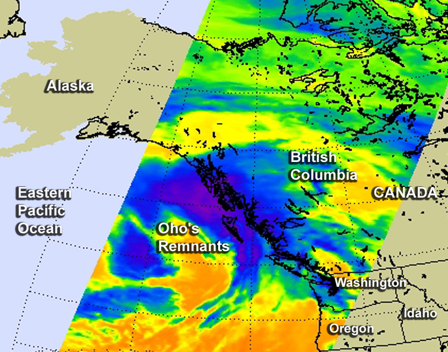
An infrared image from NOAA’s GOES-West satellite showed the clouds associated with former Hurricane Oho’s remnants near southwestern Canada and Washington State on Oct. 9 at 1200 UTC (8 a.m. EDT). An animation of GOES-West imagery from October 6 through October 9 showed the weakening and movement of Oho from the Central Pacific Ocean to the coast of western Canada. The images and animation were created by the NASA/NOAA GOES Project at NASA’s Goddard Space Flight Center in Greenbelt, Maryland.
On Oct. 9 at 6:53 a.m. EDT (1053 UTC) the Atmospheric Infrared Sounder (AIRS) infrared instrument aboard NASA’s Aqua satellite showed the high, cold clouds and storms associated with Oho’s remnants along the west coast of Canada, stretching south to the coast of Washington State.
On Friday, October 9, 2015, weather alerts were posted by Environment Canada for areas of British Columbia, and by the National Weather Service in Seattle, Washington for various areas.
Environment Canada’s alert stated “Very strong southeasterly winds of 90 to 110 km/h associated with the remnants of Hurricane Oho have developed over Haida Gwaii.” Haida Gwaii is an archipelago on the North Coast of British Columbia, Canada.
“These winds will spread to the North Coast – Coastal Sections, the Central Coast – Coastal Sections, and exposed sections of North Vancouver Island early this morning. The winds will ease later this morning to 50 to 70 km/h as the low continues to track northwards. Damage to buildings, such as to roof shingles and windows, may occur. High winds may toss loose objects or cause tree branches to break.”
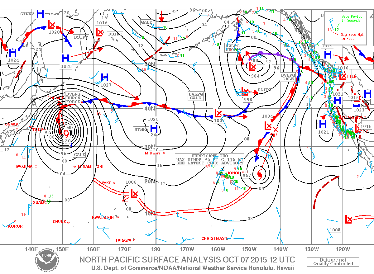
At 2 a.m. PDT on Friday, October 9, the extra-tropical remnants of Hurricane Oho were about 290 nautical miles west-southwest of Haida Gwaii.
At 6:34 a.m. EDT/3:34 a.m. PDT, the National Weather Service (NWS) in Seattle, Washington noted that a vigorous front will bring heavy rain and breezy to windy conditions Saturday and Saturday evening, October 11. The NWS discussion stated that (the remnants) “warm front offshore will move slowly through western Washington.
Most of the rain will be along the coast and in the Olympics and North Cascades (mountains) where amounts of 0.5 to 1.5 inches will be common. Locally up to 2.5 inches could fall in the Olympics. The western Washington interior lowlands will probably not get any rain until Friday afternoon (Oct. 9) and the totals through tonight will generally be less than 0.1 inch.”
For updated forecasts for Washington State, visit: http://www.weather.gov/ For updated forecasts and warnings for western Canada, visit: http://weather.gc.ca/warnings/index_e.html.
Rob Gutro
NASA’s Goddard Space Flight Center
Oct. 08, 2015 – NASA-NOAA’s Suomi NPP Sees Wind-Shear Battered Extra-Tropical Oho
Infrared data from NASA-NOAA’s Suomi NPP satellite showed Tropical Storm Oho weakening over cool waters and transitioning into an extra-tropical cyclone while being battered by strong wind shear.
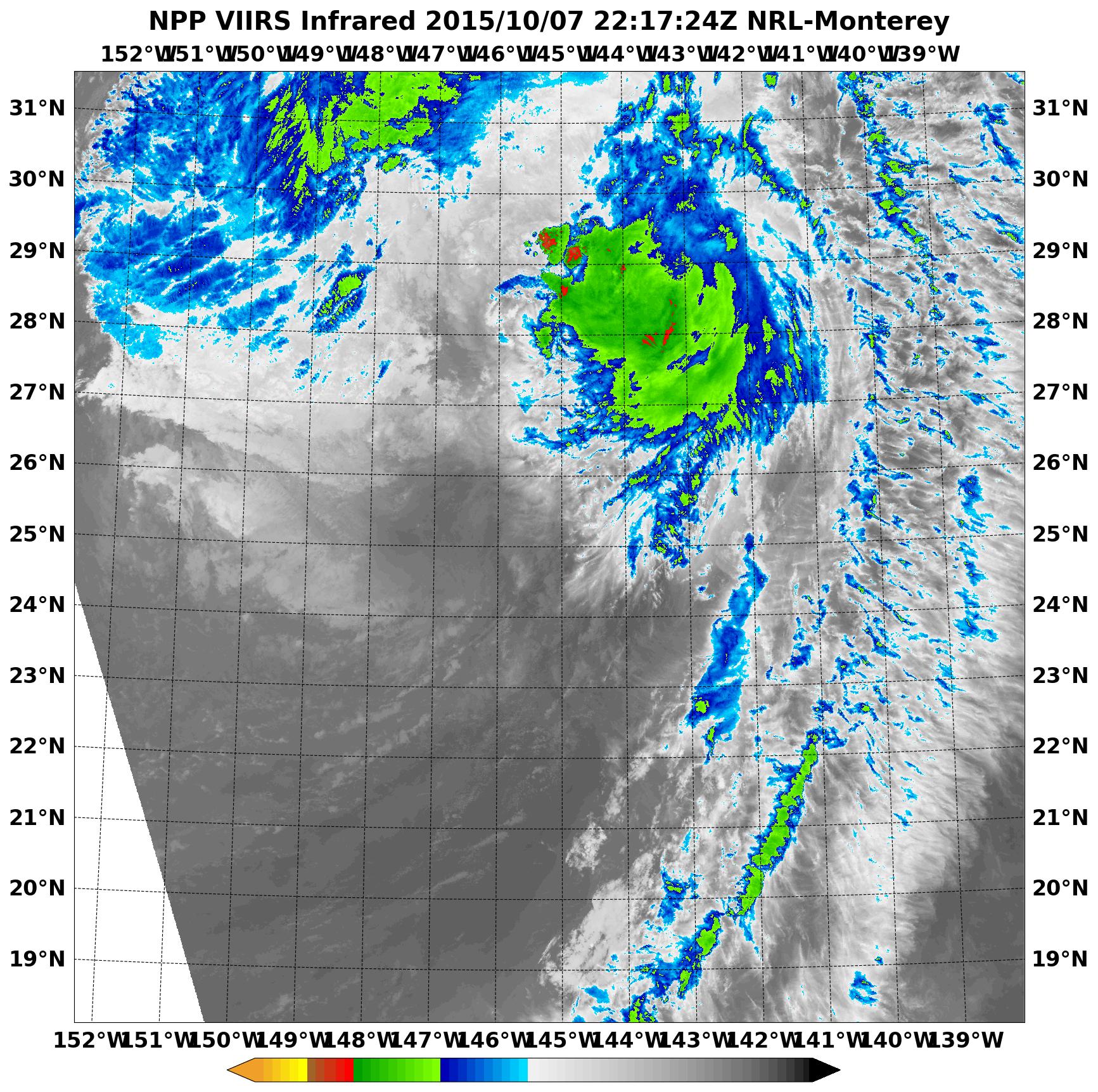
Infrared data from the Visible Infrared Imaging Radiometer Suite (VIIRS) instrument aboard NASA-NOAA’s Suomi NPP satellite showed that the remaining deep convection, clouds and showers were pushed far to the north-northeast of Oho’s center on October 7 at 2217 (6:17 p.m. EDT). That continued on October 8 as unrelenting vertical wind shear between 45 to 55 knots (51.7 to 63.2 mph/83.3 to 101.9 kph) continued to affect the storm. In addition, ships analysis showed that Oho was moving over very cool waters near 22 Celsius. Tropical Cyclones need sea surface temperatures of at least 26.6 Celsius/80 Fahrenheit to maintain intensity.
On Thursday, October 8, 2015 at 11 a.m. EDT/5 a.m. HST/1500 UTC, the center of Extra-Tropical Cyclone Oho was located near latitude 35.4 north and longitude 141.0 west. The storm is far from land areas. It is about 1,380 miles (2,225 km) northeast of Hilo, Hawaii. The extra-tropical cyclone is moving toward the north-northeast near 43 mph (69 kph) and is expected to turn to the northwest.
Maximum sustained winds are near 70 mph (110 kph) and NOAA’s Central Pacific Hurricane Center forecast calls for the storm to weaken through the morning of October 9, then strengthen late in the day and weaken again on October 10.
Becoming “extra-tropical” means that a cyclone has lost its “tropical” characteristics. The National Hurricane Center defines “extra-tropical” as a transition that implies both poleward displacement (meaning it moves toward the north or south pole) of the cyclone and the conversion of the cyclone’s primary energy source from the release of latent heat of condensation to baroclinic (the temperature contrast between warm and cold air masses) processes. It is important to note that cyclones can become extra-tropical and still retain winds of hurricane or tropical storm force.
The CPHC issued their final advisory on Oho. Future information on this system can be found in high seas forecasts issued by the National Weather Service Ocean Prediction Center at: http://www.prh.noaa.gov/hnl/pages/HSFNP.php. Residents in southwestern Canada and the U.S. Pacific Northwest should monitor the progress of this extra-tropical storm as it is expected to affect the west coast over the weekend of October 10 and 11.
Rob Gutro
NASA’s Goddard Space Flight Center
Oct. 07, 2015 – Satellite Sees the Long Arms of Hurricane Oho
Hurricane Oho appears to have extremely long arms in imagery from NOAA’s GOES-West satellite on October 7. Moisture from Oho is being drawn along a stationary front to Oho’s northeast, making it appear as if Oho is pointing toward southwestern Canada.
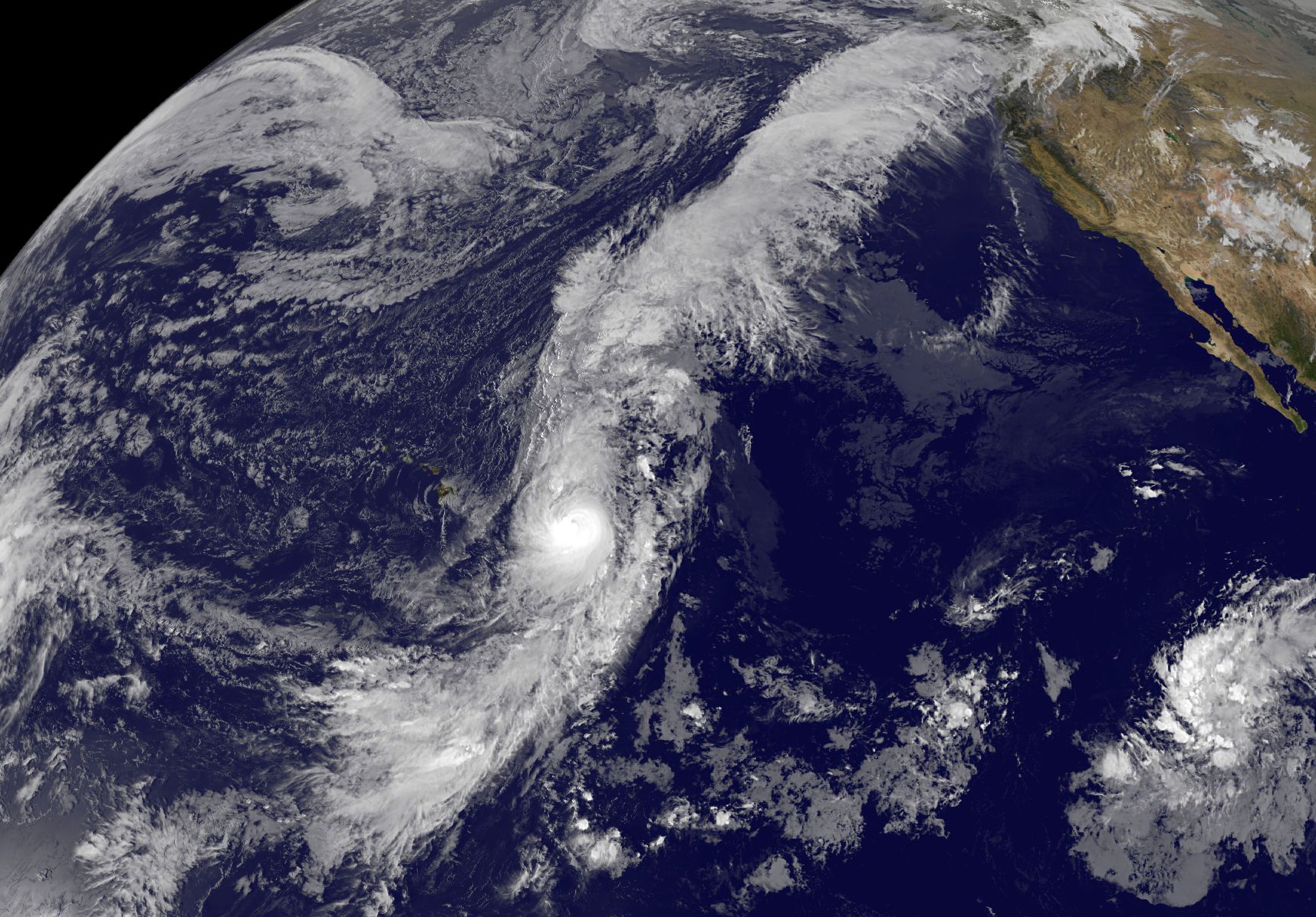
On October 7, Oho was located east of Hawaii, but outflow of clouds from the center streamed northeast along a frontal boundary all the way to southeastern Canada. The boundary is connected to a low pressure area in the Eastern Pacific Ocean, centered hundreds of miles west of southwestern Canada.
NOAA’s Central Pacific Hurricane Center (CPHC) said that Oho continued to have an eye in infrared satellite imagery early on October 7, however, the storm likely reached the peak of the Intensification since infrared data such as that from the AIRS instrument aboard NASA’s Aqua satellite have shown that the cold cloud tops surrounding the eye are warming. Warming cloud tops indicate they are dropping in altitude, and that means there is less uplift in the air – which is a sign the storm is weakening.
Oho appeared elongated from north to south in an infrared image from NOAA’s GOES-West satellite on October 7. The image was created by the NASA/NOAA GOES Project at NASA’s Goddard Space Flight Center in Greenbelt, Maryland.
At 5 a.m. HST/11 a.m. EDT/1500 UTC on October 7, the center of hurricane oho was located near latitude 23.5 north and longitude 145.9 west. That’s about 645 miles (1,040 km) east-northeast of Hilo, Hawaii. Oho was moving toward the north-northeast near 35 mph (56 kph). Oho is expected to continue accelerating toward the north-northeast during the next couple of days. Maximum sustained winds are near 110 mph. (175 kph) and is expected to weaken.
Oho is currently over sea surface temperatures of around 26 Celsius (78.8 Fahrenheit). Tropical cyclones like Oho require sea surface temperatures of at least 26.6C (80F) to maintain intensity. Cooler waters will weaken a tropical system and the latest forecast track takes the hurricane across cooler waters.
Forecaster Houston at NOAA’s CPHC said that Oho is forecast to gradually weaken during the next 24 hours. More rapid weakening is anticipated beyond 24 hours and Oho is expected to become extra-tropical by October 7 as it speeds to the northeast and Canada.
For updated forecasts from NOAA’s CPHC, visit: http://www.prh.noaa.gov/cphc.
Rob Gutro
NASA’s Goddard Space Flight Center
Oct. 06, 2015 – NASA Gets Hurricane Oho By the Tail
Tropical Storm Oho intensified into a hurricane on October 6 and appeared to have a “tail” in Infrared NASA satellite imagery. Oho is the seventh hurricane of the 2015 season in the North Central Pacific Ocean.
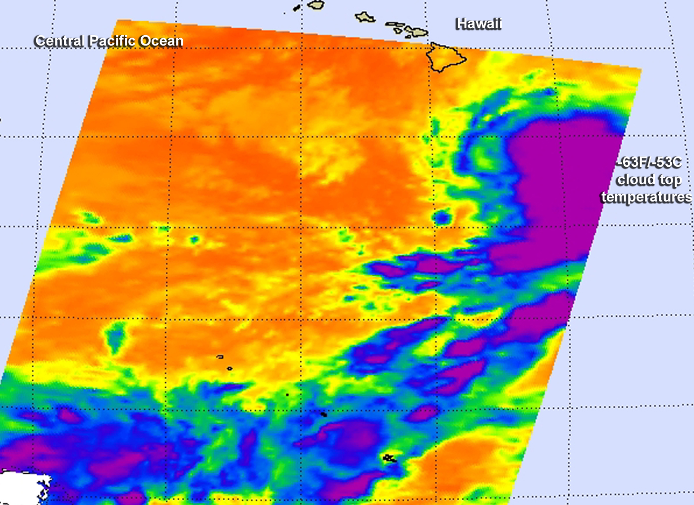
NASA’s Aqua satellite passed over Hurricane Oho in the Central Pacific Ocean on October 6 at 8:17 a.m. EDT and the Atmospheric Infrared Sounder or AIRS instrument gathered infrared data on the storm. The infrared data shows temperatures.
AIRS data showed very cold temperatures of storms with high cloud tops located somewhat east of the center of circulation and in a long fragmented band of thunderstorms that stretched from the eastern quadrant of the storm, south and west. Cloud top temperatures were as cold as -63 Fahrenheit/-53 Celsius, a threshold that indicates powerful storms with the capability to generate heavy rainfall.
Forecaster Houston at NOAA’s Central Pacific Hurricane Center noted in the discussion on Oct. 6 at 11 a.m. EDT, “the 85 Ghz channel also showed an upper level center, which appeared to be displaced slightly to the west of the low-level center.”
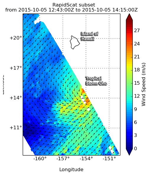
The previous day, October 5 at 10 a.m. EDT when Oho was still a tropical storm, the RapidScat instrument aboard the International Space Station measured Oho’s surface winds. RapidScat saw sustained surface winds around most of Tropical Storm Oho’s center found strongest sustained winds on the northeastern side near 24 meters per second (53.6 mph/86.4 kph).
At 11 a.m. EDT (5 a.m. HST/1500 UTC) on October 6 the center of Hurricane Oho was located
Near latitude 15.3 north…longitude 151.3 west. That’s about 395 miles (635 km) southeast of Hilo, Hawaii. Oho was moving to the east-northeast at 13 mph (20 kph) and is expected to turn toward the northeast and speed up late in the day and through October 7.
Maximum sustained winds are near 75 mph (120 kph) and some additional intensification is expected during the next day or two. The estimated minimum central pressure is 980 millibars.
The Central Pacific Hurricane Center noted that “Oho no longer appears to be a viable threat to the main Hawaiian Islands.” The CPHC forecast track takes Oho on a northwesterly route toward Oregon and Washington by Friday, October 10. For updated forecast tracks, visit: http://www.prh.noaa.gov/cphc.
Rob Gutro
NASA’s Goddard Space Flight Center
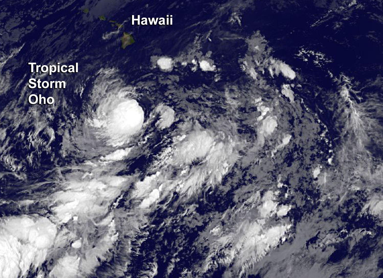
Oct. 05, 2015 – NASA Tracking Tropical Storm Oho, South of Hawaii
NASA’s RapidScat instrument that flies aboard the International Space Station saw that newly formed Central Pacific Ocean Tropical Storm Oho’s strongest side was east of its center. By October 5, NOAA’s GOES satellite saw a more circular, more uniform circulation.
Tropical Storm Oho formed at 5 a.m. HST/11 am EDT/1500 UTC on October 3, 2015. At that time the center of tropical storm oho was located near latitude 14.2 north and longitude 154.6 west, about 340 miles (545 km) south-southeast of South Point Hawaii.
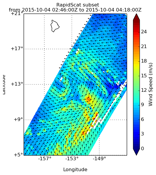
On Oct. 4 at 0300 UTC (Oct. 3 at 11 p.m. EDT) RapidScat saw Oho’s strongest winds were near 21 meters per second (46.9 mph/75.6 kph) on the storm’s southeastern side. Tropical storm force winds extended outward up to 115 miles (185 km) from the center.
On Monday, October 6 at 5 a.m. HST/11 a.m. EDT/1500 UTC the center of Tropical Storm Oho was located near latitude 14.1 north and longitude 154.6 west. Tropical Storm Oho is located about 390 miles south of Hilo, Hawaii. NOAA’s GOES-West satellite captured an infrared image of the rounded tropical storm south of Hawaii. Oho appeared to be better organized than on the previous day.
Oho was moving slowly toward the north-northeast near 2 mph (4 kph) but it is expected to turn toward the northeast later in the day. Maximum sustained winds were near 50 mph (85 kph) with higher gusts. NOAA’s Central Pacific Hurricane Center expects gradual intensification through Tuesday night, October 6. The estimated minimum central pressure is 989 millibars.
CPHC expects Oho to move to the northeast and away from Hawaii. The CPHC long-term forecast takes the system toward the northwestern U.S. as a depression by Saturday, October 10.
To the east of Oho lies another low pressure area located about 815 miles southeast of Hilo, Hawaii. Satellite data has shown that showers and thunderstorms associated with that area of low pressure are have decreased. Environmental conditions are becoming less conducive for significant development over the next two days as it moves slowly north.