The U.S. Army Corps of Engineers is proposing a $173 million project to minimize damage to Waikiki and surrounding neighborhoods if a “100-year flood” causes the Ala Wai Canal to overflow.
Such a flood — which has a 1 percent chance of occurring in any given year — would destroy 3,000 properties and cause $318 million in structural damages, according to the Corps’ newly released analysis.
That doesn’t include the economic cost to hotels and other businesses in Waikiki, the epicenter of Honolulu’s tourism economy. The Corps of Engineers report didn’t estimate the value of that business activity, but a 2003 state report found that Waikiki generates $3.6 billion in revenue annually.

Cory Lum/Civil Beat
The state and federal governments have spent more than $9 million since 2001 analyzing how to decrease flood damage, and the U.S. Army Corps of Engineers just published a 1,835-page draft environmental impact analysis and feasibility study.
Derek Chow, who leads the civil and public works branch at the U.S. Army Corps of Engineers Honolulu office, said he and other engineers considered a range of possibilities, including building a large dam in Manoa, erecting 14-foot-high walls along the Ala Wai Canal and extending the canal through Kapiolani Park.
“It will absolutely happen. It’s just a matter of when.” — Derek Chow, U.S. Army Corps of Engineers, referring to the 100-year flood scenario
They ultimately settled on a plan that calls for establishing repositories for floodwater along streams in Manoa, Palolo and Makiki, which feed into the canal. That would reduce the risk of flooding upstream while decreasing the speed and amount of water that eventually enters the canal.
The report also proposes constructing concrete walls up to 4 feet high along the canal, an idea that Waikiki state Rep. Tom Brower expects will meet resistance from some residents.
The Corps of Engineers is accepting written comments on the proposal until Oct. 7. A public hearing will be held Sept. 30 from 5 to 8 p.m. at Washington Middle School.
The project’s price tag is more than $173 million, in addition to nearly $1 million each year in operating costs. But the report stresses that the plan would save millions of dollars in the long run.
Chow says it’s only a matter of time until the Ala Wai Canal’s banks overflow, threatening the 54,000 residents and 79,000 tourists in Waikiki on any given day.
“It will absolutely happen,” he said. “It’s just a matter of when.”
The Ala Wai Canal was built in the 1920s to drain the wetlands on Oahu’s south shore, allowing the development of Waikiki. Streams in Manoa, Palolo and Makiki were diverted into the canal, elevating the risk of flooding.
The Corps of Engineers flood control plan would scatter mitigation efforts throughout the watershed rather than limiting improvements to the canal.
The proposal includes installing several in-stream detention basins, 20 to 24 feet deep, to control the flow of water within the three streams. In addition, a concrete pad, 8 feet by 60 feet, and steel posts up to 7 feet high, would catch woody debris in Manoa Stream.
The proposal also involves building earthen berms around the Kanewai Field, Hausten Ditch and Ala Wai Golf Course to collect water in the event of a flood.

Derek Chow at Woodlawn Bridge over Manoa Stream, where a wall of debris helped cause a major flood in 2004.
Cory Lum/Civil Beat
Chow said the public would still be able to use the parks and golf course, and that the flood warning system would be improved to ensure that people stay out of those areas during heavy rains.
The recommended concrete wall along the canal would be up to 4 feet high for 1.7 miles along one bank and 0.9 miles along the other bank. The report describes the walls as indispensable, and notes that the design would allow access for for canoe paddlers who use the canal.
Three pump stations would also be constructed along the canal.
Chow stressed that the plan aims to mitigate the damages but won’t eliminate all risk. For example, even with the project’s implementation, parts of Makiki would likely still be swamped during a 100-year flood.
“There will always be a flood that’s bigger than the flood we design for,” Chow said. “We will never eliminate the risk. We are trying to manage the risk to an acceptable level.”
The report lists myriad potential environmental, cultural and aesthetic impacts from the installation of flood control measures.
The construction of repositories, berms and walls might disturb the Hawaiian hoary bat, Oahu elepaio birds and Hawaiian waterbirds. And the work could disturb archaeological sites, including iwi.
Adding walls would also change the look of the historic canal.
Robert Finley, chair of Waikiki Neighborhood Board, thinks as long as the wall along the Ala Wai is well-designed, like the pillars of the rail system, it won’t be an eyesore. The wall might even have some benefits, he said.
“It would probably keep people from falling in the Ala Wai,” he said.
But Brower, who represents Waikiki in the state House of Representatives, isn’t so sure.
“I think this wall will be a very tough sell,” he said. “Because people haven’t seen a disaster in Waikiki in their lifetime, they haven’t seen a flood … There’s just a lot of optimists we have in our community.”
Brower thinks the most important way to prepare for the flood is to have an evacuation plan. He also suggests encouraging developers to build with the flood risk in mind, providing features such as elevated parking.

Courtesy of U.S. Army Corps of Engineers
Brower said he has lots of questions about the Corps of Engineers report, which he hasn’t had a chance to read yet.
“I would be happy if we just maintain what we have and make better choices that way,” he said. “Then we can think clearly about nice-to-have projects like this one.”
He emphasized that he doesn’t think that we can fight nature, and that he’s skeptical whether the wall will be effective. He also noted that the estimated $318 million in property damage isn’t that much.
“We’re a country or a state that can make that up pretty easily,” he said. “What I’m saying is that if you have a natural disaster you’re going to probably just have to take your lumps and rebuild.”
“We have to realize that the world has an imperfect environment and no matter where you live in Hawaii you’re at risk,” he said.
When the Manoa Stream overflowed in 2004, runoff from heavy rains hit a wall of debris under Woodlawn Bridge and spilled into neighborhoods. Parked cars were pushed into trees, homes were flooded and the Hamilton Library at the University of Hawaii was drenched.
Chow remembers the shock he felt surveying the damage, which totaled over $85 million. At the time, Chow was three years into developing a plan for the Ala Wai Canal. The Corps of Engineers ended up expanding the the project to take into account the risk of flooding upstream.
It’s been a long process. Changes in policy and incremental funding forced the analysis to be completed in fits and starts, lengthening the amount of time it took, Chow said.
And even if everything goes as planned from now on, it will be another six years before the project would likely break ground.
Chow said the Corps of Engineers is expected to approve a final version of the plan in January 2017 and then send it to Washington, D.C., for further review.
Funding would need to be included in Congress’ Water Resources Development Act, which tends to prioritize a backlog of projects over new proposals. The federal government would pay for two-thirds of the project, or nearly $113 million, with the state picking up the rest.
Sen. Brian Schatz, who has been working with the Ala Wai Watershed Association for the past two decades, said that if the community supports the project that he will make securing funding a high priority.
“I think it goes without saying that (the flood) would be not just an environmental catastrophe but an economic catastrophe,” he said.
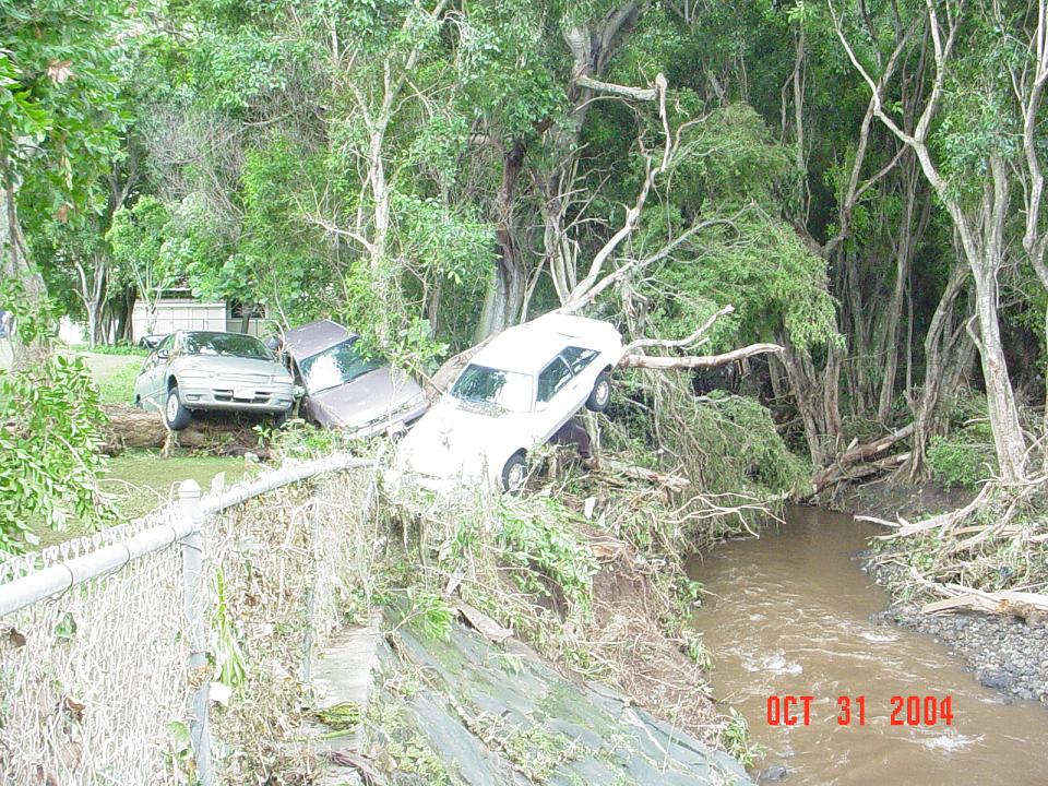
Cars stuck in trees in the aftermath of the 2004 Manoa flood.
Courtesy of NOAA
Meanwhile, the state could move forward with the design of the project as well as figuring out how to pay for its portion, nearly $60.7 million. The state would also need to cover the cost of operating and maintaining the flood control system, which is estimated at nearly a million dollars each year.
Chow said the Corps of Engineers, state and city are exploring various funding possibilities, ranging from floating bonds to asking the business community to pitch in.
For the next month Chow will focus on public outreach, talking to various community associations, neighborhood boards and politicians.
To Finley from the Neighborhood Board, helping the public learn about the project is key.
“It needs a lot of advertising,” he said. “It’s like most projects — you folks put it in the news… and when they start breaking ground, people go, ‘What’s that?'”
Click here to read the full draft environmental impact statement.


