


 South Florida will see two typical summer days — Thursday and Friday — and then it’s all about the tropics. Look for more showers and storms Thursday morning, followed by some periods of sun, highs around the 90 degree mark, and afternoon and evening storms, especially in the western suburbs of Miami-Dade and Broward, the interior, and the Gulf coast. Building ocean breezes will lead to a moderate risk of dangerous rip currents at the Atlantic beaches on Thursday, Friday, and into the weekend.
Showers and storms will also pass through early Friday morning, and then sun and clouds will reappear. Afternoon highs will be around 90 degrees, and storms will develop along a strong Atlantic sea breeze, pushing through the western suburbs of Miami-Dade and Broward and into the interior and Gulf coast.
The weekend weather shapes up to be stormy, with gusty winds and periods of very heavy rain, and those conditions could last into Monday. It all depends on the tropics and the future of the wave we’ve been watching.
 While that wave has not developed a closed circulation by early Thursday, winds of tropical storm force have been measured by the aircraft and at locations in the Leeward Islands on Wednesday.
The wave could become a tropical storm (the name would be Hermine) at any time. It is already producing heavy rainfall over portions of the Lesser Antilles, and Puerto Rico, and Hispaniola can expect periods of heavy rain as well. All of those areas face the threat of flooding and mudslides. The wave is expected to be in the southeastern Bahamas on Friday, but that’s where the certainty ends.
 Computer models are not in agreement as to track or strength beyond that point. Until a closed circulation is found and new data input into the models, we can’t be sure. However, all of us in South Florida — and especially in the storm-vulnerable Keys — should start doing those things that we know we’d have to do to prepare, because we may see weather conditions deteriorate as early as Saturday. We’ll know more once a closed circulation has formed and new data is run in the computer models, but could mean that watches will be issued with less than the usual 48 hours notice — something to keep in mind in planning for time consuming tasks like getting supplies at the last minute or, if necessary, moving boats and putting up shutters.
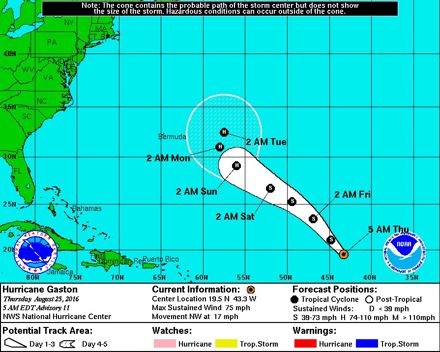 Elsewhere, Gaston reached hurricane status in the central Atlantic. At 5 am Thursday, Gaston was located near 19.5 North, 43.3 West, and was moving northwest at 17 miles per hour. Maximum sustained winds were 75 miles per hour, but some weakening is forecast.


