At a Glance
- Two tropical disturbances in the Atlantic Ocean may become a tropical depression or storm.
- One system poses a Caribbean heavy rain threat no matter whether it develops or not.
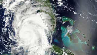
Two disturbances in the central and eastern Atlantic Ocean, Invest 99-L and Invest 90-L, are being monitored for potential development into the next tropical depression or tropical storm over the next few days.
(MORE: Hurricane Central)
These are both behind Fiona, which is succumbing to the twin tropical nemeses of dry air and wind shear far from land in the central Atlantic Ocean.

Invest 99-L: Caribbean Threat?
Invest 99-L is currently a tropical wave -- an area of low pressure without a closed, counterclockwise surface circulation -- located about 900 miles east of the Lesser Antilles.
(MORE: What is an Invest?)

So far, 99-L has had to battle against dry air, similar to Fiona ahead of it. In the last day or so, some thunderstorm clusters have been bubbling up near the disturbance.
(MORE: Why Tropical Waves Are Important During the Hurricane Season)

For a tropical cyclone to form, there needs to be persistent convection (thunderstorm activity) near a surface low-pressure circulation.
Sometimes the first system - Fiona in this case - becomes a sacrificial lamb, helping to prime the atmosphere behind it for the next system.
The National Hurricane Center says this system has a medium chance of development into a tropical depression or tropical storm over the next five days. An Air Force Reserve Hurricane Hunter aircraft is tentatively scheduled to investigate Invest 99-L on Tuesday.
For now, a tight consensus of our guidance suggests the disturbance should continue in a general west or west-northwest trajectory the next several days. It should reach the Lesser Antilles by late Tuesday or early Wednesday, and then spread through the northeast Caribbean Islands into Thursday.
(MORE: Three Things to Know About Spaghetti Model Forecasts)

Regardless of whether it is 99-L, a tropical depression or tropical storm, this system could bring heavy rain to the Lesser Antilles beginning late Tuesday. After that, it may lead to an uptick in locally heavy rain across Puerto Rico and the U.S. Virgin Islands.
Beyond that, it's possible this system may threaten the Bahamas, then eventually some portion of the U.S., but it's simply far too soon to determine.
The uncertainty is, in part, due to the fact we don't yet have a closed circulation with which numerical guidance can use as a starting point. It's hard to know where you're going if you don't know where you are.
Secondly, any low center that does form may spend time interacting with land areas of the Caribbean, which may further inhibit development.
There's a reason some of the world's best hurricane forecasters at The National Hurricane Center only issue forecasts and outlooks five days out.
To put it bluntly...
Numerical forecast models don't yet have the sufficient skill to determine the eventual track and intensity of a tropical cyclone that hasn't even formed yet while it's still thousands of miles and over a week away.
Keep that important point in mind if you see any social media posts in the days ahead suggesting any landfall more than seven days out. We wrote an example of this overhype two years ago regarding what eventually became Hurricane Cristobal.
(MORE: Where Every U.S. Hurricane Has Hit Since 1985)
Invest 90-L: East Atlantic
Much farther east, an area of low pressure associated with a tropical wave is moving away from Africa, and has better prospects for development in the near-term future.
(MORE: Hurricane Season Outlook Update)

Invest 90-L may have some dry air to fend off the next day or so, due to another Saharan Air layer.
However, the majority of our forecast guidance is suggesting 90-L is likely to develop into a tropical storm, perhaps as early as Monday.
In general, the atmospheric steering pattern in the Atlantic Ocean late this week suggests 90-L would eventually get drawn northwest into the central Atlantic Ocean, roughly analogous to Fiona, potentially becoming a hurricane.
But as we mentioned above, tropical forecasts beyond five days are fraught with uncertainty, and we can't yet write off any eventual impact to Bermuda.
We're now headed into the climatologically most active time of the Atlantic hurricane season.
(MORE: When Atlantic Season Peak Arrives)

August's Typical Origins and Tracks
This time of year, tropical waves, also known as African easterly waves, line up over Africa south of the Sahara Desert, and emerge into the eastern Atlantic Ocean.
A fraction of these tropical waves serve as the seed for an Atlantic basin tropical storm or hurricane each season.
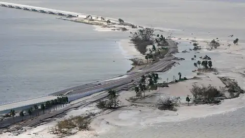
Regardless of whether either system becomes a threat, now is a good time to make sure you have a plan before a hurricane hits.
Jonathan Erdman is a senior meteorologist at weather.com and has been an incurable weather geek since a tornado narrowly missed his childhood home in Wisconsin at age 7.
MORE ON WEATHER.COM: Retired Atlantic Hurricane Names